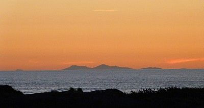
I took a nice shot of part of New Zealand's South Island from my beach in the North Island back in January, and want to figure out, from a detailed 1:50,000 topographic map, the names, locations (latitude & longitude) and heights of the hilltops in the photo.

To do this, I need to work out the angle subtended by the visible landforms on the horizon, but don't know how to do that, and guess that I'll have to count about 4000 pixels across the width of the original. Can any of our resident experts please help?
From memory, the lowest hilltops at far left and far right are around three degrees apart, but because the land was exceptionally clear (it's most often not visible) and photogenically basking in the summer twilight and looking better than I had seen it in about 50 years, I didn't think to do the usual fingertips at arm's length trick.
The camera is a Panasonic Lumix FZ40 and the zoom lens was set on 54.70mm, the equivalent of 304mm on a 35mm camera.
The detailed EXIF data the camera provides follows:
Filename - 2012-01-17 13.JPG
Make - Panasonic
Model - DMC-FZ40
Orientation - Top left
XResolution - 180
YResolution - 180
ResolutionUnit - Inch
Software - Ver.1.0
DateTime - 2012:01:17 21:06:41
YCbCrPositioning - Co-Sited
ExifOffset - 636
ExposureTime - 1/80 seconds
FNumber - 4.00
ExposureProgram - Normal program
ISOSpeedRatings - 400
ExifVersion - 0230
DateTimeOriginal - 2012:01:17 21:06:41
DateTimeDigitized - 2012:01:17 21:06:41
ComponentsConfiguration - YCbCr
CompressedBitsPerPixel - 4 (bits/pixel)
ExposureBiasValue - 0.00
MaxApertureValue - F 2.83
MeteringMode - Multi-segment
LightSource - Auto
Flash - Flash not fired, compulsory flash mode
FocalLength - 54.70 mm
FlashPixVersion - 0100
ColorSpace - sRGB
ExifImageWidth - 4320
ExifImageHeight - 3240
InteroperabilityOffset - 10798
SensingMethod - One-chip color area sensor
FileSource - DSC - Digital still camera
SceneType - A directly photographed image
CustomRendered - Normal process
ExposureMode - Auto
White Balance - Auto
DigitalZoomRatio - 0.00 x
FocalLengthIn35mmFilm - 304 mm
SceneCaptureType - Standard
GainControl - High gain up
Contrast - Normal
Saturation - Normal
Sharpness - Normal
Maker Note (Vendor): -
Thumbnail: -
Compression - 6 (JPG)
Orientation - Top left
XResolution - 180
YResolution - 180
ResolutionUnit - Inch
JpegIFOffset - 11764
JpegIFByteCount - 2445
YCbCrPositioning - Co-Sited
Another thing I want to figure out is more likely the province of navigation or surveying experts: How much of the hills' heights are showing in the photo?
The highest point is most likely Mount Stokes, 1203 metres high, and theoretically its top is 128.75 km from the camera. However, it is part of a number of ranges, so other hills in the photo might be a few kilometres closer to or further from the camera.
Geographic Range Tabels from nautical books and articles about Earth's horizon indicate that at 129 km distance, anything lower than 1121 metres would be below the horizon when viewed from sea level at my beach. The formula I use, which takes refraction into account, is: Multiply the square root of the height of the object (in metres) by 3.845821 to get its range in kilometres, so turning it around and working from the distance, 128.75km divided by 3.845821 = 33.847789718 and that squared = 1120.77 metres height.
However, none of the information I've seen mentions that most observers would have their eyes above sea level, so how does one factor in the height of the observer? At a rough guess I was around 20 metres above sea level when I took the photo. Again, I forgot to check.